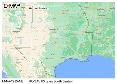
C-MAP M-NA-Y215-MS US Lakes South Central REVEAL
The C-MAP Reveal Lakes - US Lakes South Central Map Card provides detailed navigation for marine GPS systems. It features shaded relief with 3D rendered land and underwater elevation, including high-resolution bathymetric imagery. Full-featured vector charts offer accurate and up-to-date information derived from official Hydrographic Office sources. The card also includes custom depth shading and easy routing capabilities, allowing for safe and efficient navigation.
Save up to $4,000 w/Qualifying Purchases UNTIL 03/31/2024 VIEWM-NA-Y215-MS US Lakes South Central REVEAL™ Inland ChartWhether cruising or fishing or C-MA
Gallery
Attributes
| Brand name, Manufacturer name, Brand, Label, Publisher, Studio | C-MAP |
|---|---|
| Manufacturer | C-MAP Lowrance |
| KnownMan, Extra Product Name | C-MAP M-NA-Y215-MS US Lakes South Central REVEAL |
| Weight | 0.15 0.09038952742 |
| WeightUnit | lbs |
| moq, multiple, tierMinQty1, Item_package_quantity, NumberOfItems, Number_of_items, PackageQuantity | 1 |
| MPN, SKU, Keyword, Model, ModelNumber, Model_number, Mpns, PartNumber, Part_number | M-NA-Y215-MS |
| qtyInStock | 10 |
| tierPrice1 | 169.90 |
| ASIN, Asin | B08RQW66X9 |
| AdultProduct, Autographed, Batteries_included, Batteries_required, Memorabilia, TradeInEligible | False |
| Amount | 169.99 |
| Binding | Automotive sports |
| Bullet_point | CUSTOM DEPTH SHADING: Set a clear safety depth, maintain a paper-like view or create your own custom shading. EASY ROUTING: Helps you automatically plot the shortest, safest route based on detailed chart data and your personalized vessel information. No subscription required. FULL-FEATURED VECTOR CHARTS: Making navigation easy by giving you accurate, up-to-date vector chart detail derived from official Hydrographic Office information. HIGH-RES BATHY: Helps you identify shallow areas, drop-offs, ledges, holes or humps. Now includes compiled and quality-controlled Genesis detail as part of singular HRB layer. SHADED RELIEF: Bring the world around you to life, with 3D rendered land and underwater elevation – including areas of Ultra-High-Res Bathymetric imagery – a game-changer for anglers and divers. |
| ClassificationId | 3408991 |
| Color | Black |
| Currency, CurrencyCode | USD |
| DisplayName | Charts & Maps |
| Height | 0.349999999643 14.7066 1613 300 313 360 45 47 54 800 |
| Identifier | 9420064119035 |
| IdentifierType | EAN |
| IsBrandQuery | True |
| ItemClassification | BASE_PRODUCT |
| ItemName, Item_name | C-MAP Reveal Lakes - US Lakes South Central, Map Card for Marine GPS Navigation |
| Item_package_weight | 0.041 |
| Item_type_keyword | fishing-charts-and-maps |
| Length | 0.889 5.7899999940942 |
| Link | https://m.media-amazon.com/images/I/51-DadmjWCL._SL75_.jpg https://m.media-amazon.com/images/I/51-DadmjWCL.jpg https://m.media-amazon.com/images/I/513r1RwuA4L._SL75_.jpg https://m.media-amazon.com/images/I/513r1RwuA4L.jpg https://m.media-amazon.com/images/I/51KGfeiJNKL._SL75_.jpg https://m.media-amazon.com/images/I/51KGfeiJNKL.jpg https://m.media-amazon.com/images/I/51oQHc8v-SL._SL75_.jpg https://m.media-amazon.com/images/I/51oQHc8v-SL.jpg https://m.media-amazon.com/images/I/51tfAGin2zL._SL75_.jpg https://m.media-amazon.com/images/I/51tfAGin2zL.jpg https://m.media-amazon.com/images/I/61aLQRbzbiL._SL75_.jpg https://m.media-amazon.com/images/I/61aLQRbzbiL.jpg https://m.media-amazon.com/images/I/61qnJPtvTTL._SL75_.jpg https://m.media-amazon.com/images/I/61qnJPtvTTL.jpg https://m.media-amazon.com/images/I/71sgH3oQFCL.jpg https://m.media-amazon.com/images/I/71u19uNwloL.jpg https://m.media-amazon.com/images/I/81BbSdqMJRL.jpg https://m.media-amazon.com/images/I/81bYqzKZn3L.jpg https://m.media-amazon.com/images/I/81gSUZ35o-L.jpg https://m.media-amazon.com/images/I/81k4Md+JG9L.jpg https://www.amazon.com/gp/bestsellers/sporting-goods https://www.amazon.com/gp/bestsellers/sporting-goods/3408991 |
| List_price | 169.9 |
| Map_type | North America |
| Marking_type | epa_registration_number |
| Material | plastic |
| MaterialType | Plastic |
| Package_level | unit |
| Paper_finish | watercolor |
| ParentAsins | B0B17NW39X |
| ProductCategoryId | 551462 ce_display_on_website |
| ProductGroup | Automotive Parts and Accessories |
| ProductType | MAPS |
| ProductTypeName | AUTO_ACCESSORY |
| Product_site_launch_date | 2020-12-30T18:39:52.951Z |
| Rank | 128 236883 70 97061 |
| Registration_status | fifra_not_considered_pesticide |
| Size | One Size |
| Sku | C-MAP SA-D500 |
| StrippedMpns | MNAY215MS |
| Style | Us Lakes South Central |
| Supplier_declared_dg_hz_regulation | not_applicable |
| Title | C-MAP Reveal Lakes - US Lakes South Central, Map Card for Marine GPS Navigation Fishing Charts & Maps Sports & Outdoors |
| Type | VARIATION ean |
| URL | https://m.media-amazon.com/images/I/51tfAGin2zL._SL75_.jpg |
| Unit | centimeters inches kilograms pounds |
| Units | inches pixels pounds |
| Variant | MAIN PT01 PT02 PT03 PT04 PT05 PT06 |
| Warranty | 2-year warranty |
| WebsiteDisplayGroup | sports_display_on_website |
| WebsiteDisplayGroupName | Sports |
| Width | 10.4902 1280 2240 4.1299999957874 500 75 |
Distributor offers
| Seller | SKU | MOQ | In stock | Multiple | Prices |
|---|---|---|---|---|---|
| M-NA-Y215-MS | 1 | 10 | 1 | 1 @ $169.90 | |
| 87549 | 1 | 1 | 1 @ $169.90 | ||
| CMAM-NA-Y215-MS | 1 | 6 | 1 | 1 @ $169.90 | |
 delawarepaddlesports.com | M-NA-Y215-MS | 1 | -2 | 1 | 1 @ $169.90 |
| CMAPY215 | 1 | 1 | 1 @ $169.90 | ||
 cemarine.com | 87549 | 1 | 1 | 1 @ $169.90 | |
 ritelinemarine.com | 87549 | 1 | 20 | 1 | 1 @ $169.90 |
| CWR-87549 | 1 | 4 | 1 | ||
| 6083743 | 1 | 1 | 1 @ $169.90 | ||
| 0182-1297-YMLNCM9JAW | 1 | -2 | 1 | 1 @ $209.99 | |
 wateryachtsolutions.com | CMAMNAY215MS | 1 | 6 | 1 | 1 @ $169.90 |
Related on Amazon
As an Amazon Associate, we earn from qualifying purchases. (paid link) CERTAIN CONTENT THAT APPEARS ON THIS SITE COMES FROM AMAZON. THIS CONTENT IS PROVIDED 'AS IS' AND IS SUBJECT TO CHANGE OR REMOVAL AT ANY TIME.

C-MAP Reveal Lakes - US Lakes South Central, Map Card for Marine GPS Navigation
Brand: C-MAP
Details
- SHADED RELIEF: Bring the world around you to life, with 3D rendered land and underwater elevation – including areas of Ultra-High-Res Bathymetric imagery – a game-changer for anglers and divers.
- FULL-FEATURED VECTOR CHARTS: Making navigation easy by giving you accurate, up-to-date vector chart detail derived from official Hydrographic Office information.
- HIGH-RES BATHY: Helps you identify shallow areas, drop-offs, ledges, holes or humps. Now includes compiled and quality-controlled Genesis detail as part of singular HRB layer.
- CUSTOM DEPTH SHADING: Set a clear safety depth, maintain a paper-like view or create your own custom shading.
- EASY ROUTING: Helps you automatically plot the shortest, safest route based on detailed chart data and your personalized vessel information. No subscription required.
Listing
| Binding | Automotive |
|---|---|
| Product group | Automotive Parts and Accessories |
| Product type | AUTO_ACCESSORY |
| Model | M-NA-Y215-MS |
| Part number | M-NA-Y215-MS |
| Items per pack | 1 |
| Label | C-MAP |
| Manufacturer | C-MAP |