C-map max na-m023 - u.s. gulf coast & inland rivers - sd-card
Attributes
Distributor offers
| Seller | SKU | MOQ | In stock | Multiple | Prices |
|---|---|---|---|---|---|
| SavingLots | NA-M023SDCARD | 1 | 7 | 1 | 1 @ $222.50 |
 iboats.com iboats.com | IB00163802 | 1 | -2 | 1 | 1 @ $279.00 |
 Zoro Zoro | G4666917 | 1 | 1 | 1 @ $295.79 | |
| NA-M023SDCARD | 1 | 1 | 1 @ $279.00 | ||
 Anchor Express Anchor Express | 30144 | 1 | 1 | 1 @ $279.00 | |
 delawarepaddlesports.com delawarepaddlesports.com | NA-M023SDCARD | 1 | 1 | 1 @ $279.00 | |
| marine.com | 11-30144 | 1 | 1 | ||
 cemarine.com cemarine.com | 30144 | 1 | 1 | 1 @ $279.00 | |
 ritelinemarine.com ritelinemarine.com | 30144 | 1 | 1 | 1 | 1 @ $279.00 |
Related on Amazon
As an Amazon Associate, we earn from qualifying purchases. (paid link) CERTAIN CONTENT THAT APPEARS ON THIS SITE COMES FROM AMAZON. THIS CONTENT IS PROVIDED 'AS IS' AND IS SUBJECT TO CHANGE OR REMOVAL AT ANY TIME.
C-MAP MAX NA-M023 - U.S. Gulf Coast & Inland Rivers - SD-Card
Brand: C-MAP
Catalog
| Feature | 3-D View Yes |
|---|---|
| Category | Sports & Outdoors |
| MPN | NA-M023SDCARD |
| UPC | 12302644097 |
| EAN | 532065688164 |
| Product group | Health and Beauty |
| Product type | SPORTING_GOODS |
| Manufacturer | C-MAP |
C-MAP MAX U.S. Gulf Coast & Inland Rivers SD Card Electronic Charts
Brand: C-MAP
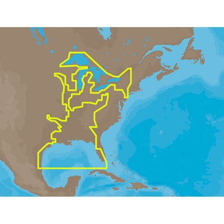
NA-M023 => Gulf of Mexico, Great Lakes and Rivers Coverage of the Gulf states, starting from Boca Raton, FL, down to Key West, FL, then back up and around the Gulf to Brownsville, TX. Also includes coverage of all the Great Lakes: Erie, Superior, Ontario, Huron and Michigan. Coverage of the Great Lakes also includes Fox River and Lake Winnebago, Lake St. Clair and the Trent-Severn Waterway. River coverage includes the Mississippi River, Ohio River, Illinois River, Arkansas River, Red River, Ouachita River, Tennessee River, Cumberland River, Tenn-Tom Waterway and the Black Warrior River. Other smaller rivers are also included: Green River, KY, Kanawha River, WV, Allegheny and Monongahela Rivers, PA and Kankakee River, IL. Additional coverage of the Hudson River, including Lake Champlain, down to New York City, the Erie Barge Canal and partial coverage of the St. Lawrence River up to Montreal.
Details
- C-Map Na-M023 Sd Card Format Us Gulf Coast & Inland Rivers