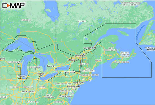
C-MAP M-NA-Y201-MS Great Lakes To Nova Scotia REVEAL
Gallery
Attributes
Distributor offers
| Seller | SKU | MOQ | In stock | Multiple | Prices |
|---|---|---|---|---|---|
| M-NA-Y201-MS | 1 | 1 | 1 | 1 @ $249.90 | |
| 87524 | 1 | 1 | 1 @ $249.90 | ||
| CMAM-NA-Y201-MS | 1 | 4 | 1 | 1 @ $249.90 | |
 delawarepaddlesports.com delawarepaddlesports.com | M-NA-Y201-MS | 1 | -2 | 1 | 1 @ $249.90 |
| CMAPY201 | 1 | -2 | 1 | 1 @ $249.90 | |
 cemarine.com cemarine.com | 87524 | 1 | 1 | 1 @ $249.90 | |
 ritelinemarine.com ritelinemarine.com | 87524 | 1 | 15 | 1 | 1 @ $249.90 |
| CWR-87524 | 1 | 1 | |||
 lg-outdoors.com lg-outdoors.com | 6083730 | 1 | 1 | 1 @ $249.90 | |
 wateryachtsolutions.com wateryachtsolutions.com | CMAMNAY201MS | 1 | 3 | 1 | 1 @ $249.90 |
Related on Amazon
As an Amazon Associate, we earn from qualifying purchases. (paid link) CERTAIN CONTENT THAT APPEARS ON THIS SITE COMES FROM AMAZON. THIS CONTENT IS PROVIDED 'AS IS' AND IS SUBJECT TO CHANGE OR REMOVAL AT ANY TIME.

C-MAP Reveal Coastal - Great Lakes to Nova Scotia, Map Card for Marine GPS Navigation
Brand: C-MAP
Details
- SHADED RELIEF: Bring the world around you to life, with 3D rendered land and underwater elevation – including areas of Ultra-High-Res Bathymetric imagery – a game-changer for anglers and divers.
- FULL-FEATURED VECTOR CHARTS: Making navigation easy by giving you accurate, up-to-date vector chart detail derived from official Hydrographic Office information.
- HIGH-RES BATHY: Helps you identify shallow areas, drop-offs, ledges, holes or humps. Now includes compiled and quality-controlled Genesis detail as part of singular HRB layer.
- CUSTOM DEPTH SHADING: Set a clear safety depth, maintain a paper-like view or create your own custom shading.
- DYNAMIC RASTER CHARTS: Providing the traditional chart look and feel, coupled with easy access to all objects on the chart.
Listing
| Binding | Sports |
|---|---|
| Product group | Sports |
| Product type | GPS_OR_NAVIGATION_SYSTEM |
| Model | M-NA-Y201-MS |
| Part number | M-NA-Y201-MS |
| Items per pack | 1 |
| Label | C-MAP |
| Manufacturer | C-MAP |