Humminbird . 600017-4
Gallery

Attributes
Distributor offers
| Seller | SKU | MOQ | In stock | Multiple | Prices |
|---|---|---|---|---|---|
| Wholesale Marine | XHUM-600017-4 | 1 | 1 | 1 @ $149.99 | |
| SavingLots | 600017-4 | 1 | 5 | 1 | 1 @ $127.50 |
| westmarine.com | 17729864 | 1 | 1 | ||
 Zoro Zoro | G4508658 | 1 | 1 | 1 @ $149.99 | |
| 600017-4 | 1 | 15 | 1 | 1 @ $93.79 | |
| boatersplus.com | NW-3005.8810 | 1 | 1 | ||
| delawarepaddlesports.com | 600017-4 | 1 | 1 | ||
 Zoro Zoro | G401990112 | 1 | 1 | 1 @ $149.99 | |
| campingworld.com | 332875 | 1 | -2 | 1 | |
| marine.com | 11-57863 | 1 | 1 | ||
| 57863 | 1 | 1 | |||
| HUMMINBIRD LAKEMASTER -600017-4 | 1 | -2 | 1 | 1 @ $107.14 | |
| 600017-4 | 1 | 1 | 1 @ $149.99 | ||
| primebuy.com | 600017-4 | 1 | 1 | ||
| cemarine.com | 57863 | 1 | 1 | ||
 ritelinemarine.com ritelinemarine.com | 57863 | 1 | 43 | 1 | 1 @ $136.99 |
| unitedoutdoorsupply.com | 3005.8810 | 1 | Out of stock | 1 | 1 @ $149.99 |
| HUM-600017-4 | 1 | 1 | 1 @ $149.99 | ||
| 082324048128 | 1 | -2 | 1 | 1 @ $144.99 | |
| 600017-4 | 1 | 1 | 1 @ $108.28 | ||
| 5920618 | 1 | 1 | 1 @ $101.26 | ||
 wholesalehunter.com wholesalehunter.com | 11115062 | 1 | 1 | 1 @ $0.00 |
Related on Amazon
As an Amazon Associate, we earn from qualifying purchases. (paid link) CERTAIN CONTENT THAT APPEARS ON THIS SITE COMES FROM AMAZON. THIS CONTENT IS PROVIDED 'AS IS' AND IS SUBJECT TO CHANGE OR REMOVAL AT ANY TIME.

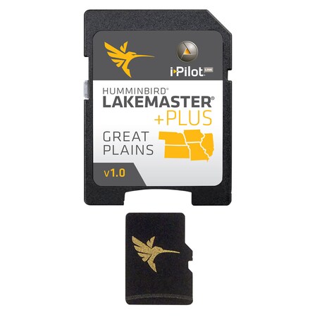
Humminbird 600017-4 LakeMaster PLUS Great Plains V1 Digital GPS Maps Micro Card
Brand: Humminbird
Details
- Get an added angling advantage with LakeMaster Plus mapping, which adds high-quality aerial photography to its unrivaled accuracy and detail, easy-to-read contours, highlighted depth ranges, and scrollable lake lists. D40
- This LakeMaster Plus Great Plains Edition, Version 1 boasts more than 400 high-definition lakes and over 500 total lakes from NE, KS, MO, IA, and IL.
- LakeMaster Plus enables you to view an aerial image overlay on high-definition waters to see the entry and exits of creek channels, to see how far a reef or weed line extends, and to pick out shallow-water rock piles, steep drop-offs, and other features.
- Easy-to-see shading highlights shallow-water areas within an adjustable range up to 30 feet, and depth contours and shorelines can be synchronized with the actual water levels of lakes, reservoirs, and rivers.
- LakeMaster Plus digital maps come on a Micro SD card (with included SD card adapter) that's compatible with all GPS-equipped HELIX, SOLIX, ONIX, and ION Series models and select 600-1100 Series models.
Listing
| Binding | Sports |
|---|---|
| Product group | Wireless |
| Product type | FISHING_EQUIPMENT |
| Model | 600017-4 |
| Part number | HCILIAP1 |
| Items per pack | 1 |
| Label | Humminbird |
| Manufacturer | Humminbird |